


2017/12/13

NASA(アメリカ航空宇宙局)の公式発表記事を意訳を避けできるだけ忠実に翻訳します。
オリジナルURL:Dawn LAMO Image 51
画像クリックで拡大表示(1024×1024)します。
Image credit: NASA/JPL-Caltech/UCLA/MPS/DLR/IDA
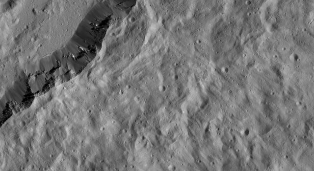
This image, taken by NASA’s Dawn spacecraft, shows the southeastern rim of Occator Crater. This 57-mile- (92-kilometer-) wide crater is of high interest because of its bright spots, which are not pictured here.
Compacted material forms spurs along the crater wall. A group of roughly parallel, braided fractures can be seen on the crater floor at top center. Additional fractures, more muted in their appearance, are visible near upper right and lower left. The crater’s ejecta blanket, which spreads away from the rim toward lower right, is peppered mostly with very small-scale impact craters.
The Dawn spacecraft took this image on Jan. 26, 2016, from its low-altitude mapping orbit, at a distance of about 240 miles (385 kilometers) from the surface. The image resolution is 120 feet (35 meters) per pixel.
NASAのドーン探査機が撮影したこの画像は、オッカトルクレーターの南東の縁の部分です。この57マイル(92キロ)の幅のクレーターは、ここに写っていませんが、発光部があるクレーターのため、高い関心を集めています。
クレーターの壁面に沿って圧縮された物質が吹き付けられたような状態になっています。画像の上の方の中央部にだいたい平行に並んだ感じで、折れ曲がった骨組みのようなものが見えます。よく見ないと分かり難いのですが、同じような骨組みのような切れ端が、画像の右上と、左下の方にも見れます。クレーターから噴き出されたブランケットのように見えている堆積物はクレーターの縁から右下の方向へ広がっています。
ドーン探査機はこの画像を、2016年1月26日にセレスの軌道上で、地表から約240マイル(385キロ)の距離から撮影しました。低高度マッピング軌道から、このイメージを取りました。画像の解像度はピクセルあたり120フィート(35メートル)です。
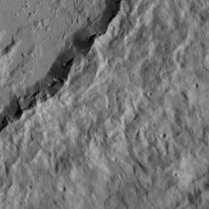
記事に記載されている骨組みのような、あるいは木の枝のようにも見えるものは、画像を拡大してご覧ください。確かに奇妙な地形です。
NASAのコンテンツ使用の規約上、NASAのオリジナル画像を編集できませんが、その部分を拡大すると上図になります。
sponsored link
more
2017/12/13

2017/03/24

2017/03/09
more
2017/12/13

2016/11/19

2016/11/18
more

2016/03/21

2016/03/21

2016/03/21